Washington State Department of Transportation is engaged in “I-5 Tumwater to Mounts Road Planning and Environmental Linkages (PEL) Study.’
Additional documents include the 2018 Corridor Capacity Report, Interstate 5 Tumwater to Mounts Road PLANNING AND ENVIRONMENTAL LINKAGES STUDY, and INTERSTATE 5: TUMWATER TO MOUNTS ROAD MID- AND LONG- RANGE STRATEGIES.
There are hundreds of pages of material, but in short, WSDOT wants to add a lane in each direction between Mounts Road and Marvin Road across the Nisqually Delta.
The project is being promoted as ecologically friendly because a bridge will replace some of the fill. opening wetlands to tidal flow. The primary purpose is relieving traffic congestion on I-5, specifically adding a lane in each direction to I-5. The project may interfere with BNSF freight rail traffic and preclude improvement of the Amtrak Cascades service that uses the Sound Transit route between Tacoma and Nisqually.
This is not a good project in many ways. It is contrary to state environmental policy, a state law requiring a reduction in Vehicle Miles Traveled, and a Governor’s Executive Order on climate emergency policy.
The comment period ends June 30. The comment page of the WSDOT website for this project is https://engage.wsdot.wa.gov/i-5-marvin-to-mounts-pel/comments/. There is also a direct email address: ORI-5Tumwater-Mounts@wsdot.wa.gov
Please comment against this damaging highway project. There are alternatives that weren’t considered, since the original goal was the increase in vehicle capacity, not how to move people and freight.
If you desire, please feel free to use my comments on this project:
The Planning and Environmental Linkages study appears to be designed to support a predetermined conclusion that lanes must be added to I-5 through the study area. The environmental attributes of the project appear to be coming along for the ride on the highway project.
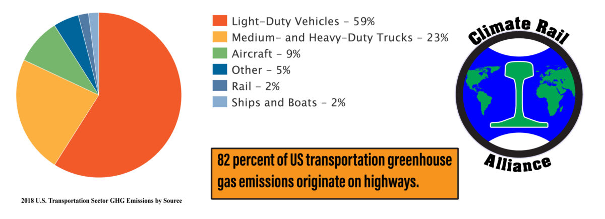
Climate Change
The climate change effect of the I-5 Marvin to Mounts Road project has not been appropriately considered.
The United Nations Intergovernmental Panel on Climate Change has issued several reports over a period of more than a decade, stating that greenhouse gas emissions must be reduced by about 50 percent by 2030 to prevent irreparable climate damage.
Action by the Legislature and the Governor includes the following:
RCW 70.45.020 (2008) requires greenhouse gas emissions reductions that have not been met. Greenhouse gas emissions have increased.
RCW 47.01.440 (2008) adopts a statewide vehicle miles traveled reduction goal of 18 percent by 2020.
(Vehicle Miles Traveled (VMT) in 2020 was only two percent less than in 2008.)
Executive Order 09-05 directs the Secretary of the Department of Transportation to:
(a)… and develop additional strategies to reduce emissions from the transportation sector.
(b)… develop and adopt regional transportation plans that will, when implemented, provide people with additional transportation alternatives and choices, reduce greenhouse gasses and achieve the statutory benchmarks to reduce annual per capita vehicle miles traveled in those counties with populations greater than 245,000.
The Purpose and Need statement:
The Purpose and Need statement defines the transportation problem to be solved as improved mobility for vehicles:
- Enhance mobility and connectivity on I-5 for passenger vehicles, freight, transit, and active transportation modes and provide support for increased person and freight throughput.
This statement is inconsistent with the need to reduce greenhouse gas emissions by 50 percent by 2030 and with RCW 47.01.440 and Executive Order 09-05.
The study provides evidence that supports the proposed solution to the transportation problem defined in the Purpose and Need statement, movement of vehicles on the highway. Transportation of individual people is treated as an ancillary subject.
The environmental element of the project is listed third in the Purpose and Need statement.
- Enable environmental restoration and ecosystem resiliency at the I-5 crossing of the Nisqually River Delta area.
The fourth element of the Purpose and Need statement appears to assume that this project will cause the stated result stated in that elemen:.
- Support economic vitality through reliable and efficient freight movement and access to major employers.
Most of the Washington State climate change policies are centered on mitigation of the effects of climate change rather than prevention. Washington State Greenhouse Gas Emissions have increased by 3.3 percent since 2010 despite RCW 70A.45.020 requiring reduction. The mitigation approach is not sustainable. Failure to make the immediate reductions in greenhouse gas emissions as described by IPCC can eventually lead to catastrophic changes for which there is no mitigation.
HOV Lanes and widening
The Alternatives Evaluation Memorandum, Final May 2023 states:
Alternative 2—Widening for managed/HOV Lanes was identified as the preferred alternative and is recommended for advancement into NEPA. This alternative adds one HOV lane in each direction from Marvin Road to Mounts Road and performed higher overall in the detailed evaluation….
Alternative 2 includes adding a highway lane in each direction. Although the stated purpose of the additional lanes is HOV travel, additional lanes are not consistent with VMT reduction. An appropriate approach would be to restrict an existing lane in each direction to HOV travel.
The Interstate 5 Tumwater to Mounts Road PLANNING AND ENVIRONMENTAL LINKAGES STUDY (2022) demonstrates a substantial increase in traffic volume as a result of the proposed changes.
To be consistent with RCW 47.01.440 and Executive Order 09-05. the evaluation criteria for a project should not be qualitative as they are in the evaluation rating methodology. “Accommodates Active Transportation” and “Accommodates Transit Modes,” merely demonstrate that these elements can be accommodated, not that the project will affect mode shift.
The data presented counts vehicle trips but does not indicate how many of those vehicles qualify as HOV. Therefore there is insufficient data to assume that the HOV lanes will be effectively used.
The transit network analysis is also only qualitative. There is a map showing bus lines that do not affect the traffic in the study area and cites transit trips representing 1.9 percent of daily travel. The discussion cites one bus route affected by the study area, Intercity Transit Route 620. The Gillig buses used by Intercity Transit appear to have a capacity of 40 passengers. There are three peak period trips north, at 6:00am, 6:50am, and 7:55am. The southbound peak period trips leave Lakewood at 3:30pm, 4:40pm, and 5:40pm. This service is insufficient to attract significant ridership. JBLM is cited as a key subarea with 106,000 off-site vehicle trips per day. JBLM is not served by transit to/from Thurston County. Pierce Transit provides service between the Lakewood Transit Center and Madigan Hospital. There is no data regarding JBLM origin/destination or how many of the vehicle trips qualify for the proposed HOV lane use.
There is no information in the evaluation that indicates that the HOV lanes will reduce congestion. Were the HOV lanes to be effective in their stated purpose, additional lanes would not be needed.
The evaluation provides no evidence to substantiate the claim that the project increases person and freight throughput as stated in the evaluation rating methodology. The claim that it does so appears to be based upon the assumption that the mere presence of the HOV lane will cause a significant number of vehicles to move from the general traffic lanes to the HOV lanes. Were that to occur, additional lanes for HOV would not be needed.
Active Transportation
The evaluation states that the preferred alternative provides for low stress active transportation. The illustrations represent a shared use path separated from a 60 mph traffic lane by a concrete barrier approximately four feet tall and the eleven foot highway shoulder. There is a vast difference between walkable and having the facilities for walking. The proposed configuration cannot be described as a low stress or healthy environment. The study does not explore origins/destinations for active transportation. The potential origins/destinations are limited in this area. It appears that the major use may be for observing the wildlife area, but it checks the pro forma active transportation box for a highway project.
Safety
BNSF railroad crossing, Option 1, suggests achieving four lanes through the BNSF bridges by reducing lane and shoulder widths. A short segment with reduced lane and shoulder widths without reduced speed will increase the hazard of collision. However, this is not discussed.
Public transportation, bus or rail, is substantially safer than automobile travel. The fatal Amtrak Cascades derailment in the study area in 2017 was the first fatal passenger train incident in Washington since 1910. There were two Washington State highway accident fatalities per day in 2022. In general, a transit rider has one-tenth the injury or fatality risk of a person in an automobile. The risk assessment in this study considers only the relative safety of alternatives presented in the study within the most dangerous mode of travel.
Railroad Crossings
Option 2 involves replacing existing BNSF bridges to accommodate the additional lanes. There are obstacles, as cited, however; there should be no hesitation to do the railroad part of the project correctly, just as there appears to be no apprehension about the extensiveness of the highway project.
Option 3 involves new I-5 bridges over the BNSF tracks.
The discussion of Sound Transit describes building new bridges for the Sound Transit track adjacent to the existing bridges.
Neither Option 3 nor new Sound Transit bridges parallel to the existing Sound Transit bridges are acceptable.
The project area must be able to accommodate the existing Sound Transit track for future use by freight trains or as a siding as necessary, and a new 100 mph alignment connecting the Sound Transit track at Mounts Road with the BNSF track on the south bank of the Nisqually River. This arrangement has been part of the Amtrak Cascades plan since 1992. DOT currently claims that there is no intention of constructing this new alignment. Given that statement, an unacceptable outcome of the current preliminary planning for the Cascades Service Development Plan is likely. The future of effective rail transportation must not be diminished or precluded by a highway project in response to current political whims.
DOT has been dismissing the climate emergency response potential of the Amtrak Cascades program as it was planned and developed decades ago, while instead promoting and funding the Ultra High Speed Ground Transportation program that is not a climate emergency response.
Transit and Public Transportation
Highway travel is not limited by political boundaries as is public transportation. This project purports to accommodate public transportation but does nothing to facilitate, encourage, or create public transportation. Sound Transit has no concern for transportation needs south of DuPont. Pierce Transit provides no service into Thurston County. Intercity Transit provides ineffective service between Thurston and Pierce Counties. Yet, for traffic between Thurston and Pierce Counties, more highway lanes are considered necessary. That is irrational and unacceptable.
State funds could be used to promote HOV use through transit and vanpool funding. A more appropriate climate emergency response would be to fund rail transit between Lacey and Tacoma and between Olympia and Tacoma. The Olympia service would use an improved existing rail line. The Lacey service would use an improved existing rail line and a rail line added to the Woodland Trail that is on the alignment of an abandoned rail line. The rail/trail shared right of way is much safer and more pedestrian friendly than the proposed walkway along I-5 in the project area, so should not be objectionable.
The Amtrak Cascades service, given the improved infrastructure of the Long Range Plan for Amtrak Cascades (2006) could provide additional early northbound service between Olympia/Lacey or Centralia and Seattle by utilizing equipment sets that overnighted in Seattle prior to their first trip of the full route service day.
The state could explore the feasibility of truck shuttle trains, similar to those used in, for example, in the mountainous areas of Austria and Switzerland.
Were there true interest in addressing climate change, congestion, travel time, and safety, the funds would be invested in effective public transportation as described instead of new highway lanes.
These improvements would satisfy the purpose and need of facilitating the movement of people rather than the declared purpose and need of facilitating the movement of vehicles. Further study of Commuter Rail, Light Rail, Monorail, and subway/BART-type system is proposed in the mid- and long-range strategies report. However, climate change is not a mid- or long-term problem. Existing facilities can be modified to provide effective short-term results as described above.
Benefits
The planning-level cost estimate for this project is $1.7 billion. The benefits are described in relative terms, not quantified. There is no examination of the benefits for similar cost rail and bus transit projects.
Conclusion
The study appears to be designed to justify a highway widening project with a secondary potential environmental benefit. It is not an effective climate emergency response and is not consistent with RCW 47.01.440 and Executive Order 09-05.
This project should not move forward. There must be appropriate and rapid extensive study of more effective climate emergency responses that are consistent with RCW 47.01.440 and Executive Order 09-05, which should include the Point Defiance curve revision and high speed track from Nisqually to Centralia, as outlined in the taxpayer-funded Long Range Plan for Amtrak Cascades (2006) and should not include additional traffic lanes on I-5.
Thomas White
Co-founder, Climate Rail Alliance
taw@climaterailalliance.org